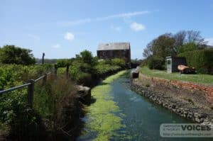
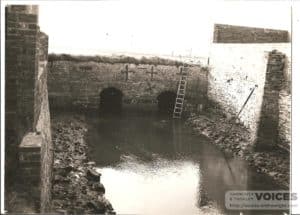
Thorley Brook was once a navigable creek leading off the Western Yar almost as far as Thorley Manor until it silted up and a causeway was built across its entrance where a tide mill was established in the mid 17th century and the current one at the end of the 18th century.
The Freshwater, Yarmouth and Newport railway was opened in1889 and ran across the marsh, under the Thorley Road and on the edge of the marsh, north of Thorley Manor before continuing on higher ground towards Newport.The mill, the mill causeway and the railway line all had an effect on how Thorley brook and the marshes around it would operate in the future. The marshes act as a flood plain to the catchment area of the Thorley brook which in itself divides to the north of Thorley Manor, the main arm towards Thorley Street and the small watershed east of Broad lane, the lesser arm to Cranmore.
The drainage of the flood plain back to the main watercourse was laid out in a series of ditches fed by shallow runnels back to a feeder ditch running parallel to the Brook. This ditch is in turn emptied back to the brook by a series of hinged flap sluices which open when the brook level is low enough. The brook level lowers when the tide goes out allowing the two sets of sluices one at the station and one by the mill connected by the mill race to open. This was the original means of driving the mill wheel. My interest in the Marshes began in February 1969 when I arrived on the Island following a very wet autumn and winter, to manage the Thorley Manor Farm of which the marshes were an integral part.At this point the marsh drainage system was in a poor state of repair and as the farm’s intention was to graze a single suckled beef herd on these marshes in the summer, housing them in the winter when the marshes were flooded, it was essential to have it returned to its original state. The main brook course was controlled and maintained by the River Authority and so they dredged the brook using a tracked drag line on mats, putting the spoil along the banks raising the level of the banks and increasing the capacity of the brook.
The sluice gates were repaired and the feeder ditches were dug out and fenced to prevent treading in by cattle. This in turn created a series of paddocks which allowed a rotational system of grazing for the livestock.This made a great improvement to state of the ground at all times of the year, so that as it continued to act as a flood plain in winter, it dried out in a good condition in the Spring. Access for cattle and for footpath users was greatly improved.
In the Spring if heavy rainfall coincided with the neap tides the emptying time of the brook to the estuary was much reduced and increased during the time of the spring tides. This could result in delaying the cattle grazing in the Spring by up to 3 weeks, a critical factor in the management of the herd. A further improvement to the drainage was carried out to reduce this delay. The feeder ditch was dug deeper to increase its holding capacity from the station to the back of Thorley Manor. A series of three pumps controlled by level switches were installed near the station. This allowed water to be pumped from the marsh into the brook over the bank before the level of the brook had fallen to allow the minor sluices in the banks to open. (The difference in level between the pump site and the back of the Manor is only one foot. It is worth noting that if the main sluice gates at the mill and the station failed, the salt water would reach Hill Place lane and beyond, at high tide.) We had now gained in most years, 3weeks extra grazing in the Spring and two weeks in the autumn.On the upper reaches of the brook the grazing was improved by re-seeding, and the major perennial weeds of dock, thistle and ragwort were controlled by topping before they seeded.
By this time the beef suckler herd had been increased to 100 cows, with half calving in the autumn and the other half in the spring, with two thirds of their grazing being on the marshes.
In the mid 1990’s a high percentage of the marshes were declared a site of special scientific interest (SSSI) and although the Thorley Brook remained as a main waterway under the River Authority the ultimate control passed to English nature. This affected the level and timing of the dredging and drainage. The amount of silt and plant growth which now accumulated in the brook meant that the banks of the brook now needed fencing to avoid cows and calves falling in and getting trapped there. This extra cost of erecting and maintaining these fences would eventually make the cattle an uneconomic venture. In 1999 all the cattle were sold following a change of the farm ownership, the pumps were switched off, and in time it is likely that the marshes will revert to its state of 30 years previously.Andrew Johnson 28-5-2013


